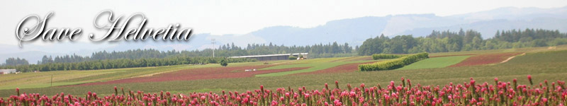
Historic and Cultural Areas
Candidate Reserve Study Area
Washington County, North of Highway 26
August 20, 2009
Submitted by . . . . . . . . . . . . . . . . . . . SaveHelvetia.org
A local citizens' group whose goal is to preserve all land north of Highway 26 as Rural Reserves
Justification for designation as RURAL RESERVES under
RR (3) (e) Provide a Sense of Place for the Region
per OAR 660-027-0060(3)(e)
|
Definition includes Historic and Cultural Areas
The Land Conservation and Development Department, Division 27 of the Oregon Administrative Rules, describe factors that a region must consider when choosing lands for designation as urban or rural reserves. (1)
Important natural landscape features are further defined in OAR 660-027-0010(6):
... "These features include, but are not limited to, ... historic and cultural areas; and other landscape features that define and distinguish the region."
This document describes the historic and cultural areas and features that define the area north of Highway 26 and distinguish this region within the Willamette Valley.
Note: The area under discussion in this paper includes the following approximate boundaries:
South: Highway 26
East: Eastern edge of Washington County line
North: Tualatin Mountains (vicinity of Skyline Blvd.)
West: Mountaindale Road, east of North Plains
|
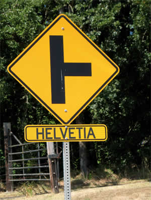
Historic Helvetia
The area north of Highway 26 known as "Helvetia" is bordered on the north by the Tualatin Mountains. This continuous green corridor that runs from Forest Park out to the Coast Range can be seen from anywhere in the valley. It contributes to a unique visual sense of place. This area is a rich habitat of plant and wildlife. The elk herds and the Oregon white oaks provided shelter and sustenance to the Atfalati people. The pioneer settlers and later the Swiss German immigrants started a rich farming tradition that continues today. The farmhouses, churches and barns they constructed in the 19th century can still be seen in their original rural setting, carefully maintained and in continual use for more than 100 years. This rich historical and cultural heritage is reflected in the historical buildings and sites that can be found throughout the Helvetia area north of Highway 26.
National Register of Historic Places
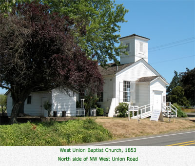
West Union Baptist Church
Richard and Helen Rice Residence (Rice Museum)
Century Farms
Eli Davis Century Farm, 1847
Batchelder Century Farm, 1858
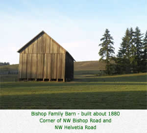
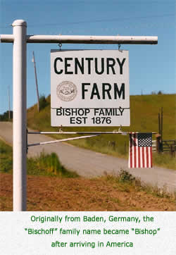
Bishop Century Farm, 1875
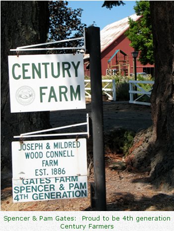
Joseph & Mildred Wood Connell II Century Farm, 1886
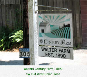
Walters Century Farm, 1890
Abraham Yungen Century Farm, 1890
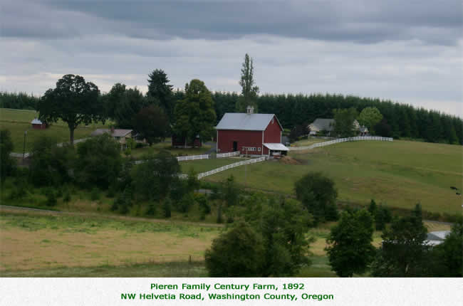
Pieren Century Farm, 1892
Cropp Century Farm, 1907
State of Oregon Historic Buildings
Helvetia Community Church, 1899
Jackson Grist Mill Site - 1850's
Washington County Cultural Resource Inventory
Blanchard/John Zeis Farmhouse, 1890
Jossi Residence and Farm, 1890
Logie Trail
Cowaniah's Battlefield, 1860
Bolin/John Tschaabold House, 1895
Tschabold Farm Complex, 1890
Joseph/Thomas Connell Farm, 1886
Meek Maples, 1850's
George Hemmy Residence, 1901
Pubols Barn, 1860-1870
Helvetia Community Hall, 1915
Helvetia Tavern, 1890's
Historic and Cultural Areas: Pre-Settlement
The area north of Highway 26 served the the Atfalati people in several ways. The Cha-takuin, "place of big trees", is now known as "Five Oaks". It was one of the camping spots the Atfalati used in their seasonal travels from their winter towns surrounding Wapato Lake near Forest Grove to the Tualatin Mountains. During the summers and falls, the Atfalati would camp at Cha-takuin and pick berries and acorns throughout the area north of Highway 26. (13)
The Atfalati created trails for traveling from the Tualatin Valley floor over the Tualatin Mountains to the Columbia River. The trails later became present-day NW Logie Trail, NW Bishop Road and NW Cornelius Pass Roads. Residents throughout the 20th century found numerous relics of Native American life along these roads: arrowheads, beads, shells. At least one Cultural Site is located within this area. Its location has been protected by the farmers and its land left undisturbed for the last 150 years.
|
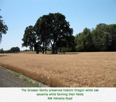
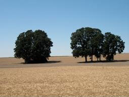
Oregon white oak savanna
NW Helvetia Road |
Near the proposed candidate urban reserve area lies the site of Cowaniah's Battlefield. (2) During the late 1850's, bands of Klickitat Indians from Washington State would cross the Columbia River and raid the Willamette Valley, entering by way of Logie Trail.
Local history has it that Charles Cowaniah, an Indian homesteader who resided on what was to become Helvetia Road, organized a group of white and Indian residents to repel the Klickitat invaders.
The battle, which occurred in 1860, was brief, but Cowaniah had his horse shot out from beneath him. Old timers say that, as young children, they could see the bones of Cowaniah's horse in the bushes. The surprise encounter with the group of valley residents sent the Klickitats fleeing on horseback over the hills to the Columbia River.
The Oregon white oak savannas found throughout the area north of Highway 26 provided shelter and sustenance to the Atfalati. In the fall, the Atfalati would gather acorns that fell from the giant Oregon white oaks, crushing them into a meal, or mush.
Historic Landmarks: NW West Union Road
 Before Oregon attained statehood in 1859, a number of buildings were erected by the pioneers as they settled down to life in the land north of Highway 26. Local residents have carefully used them and meticulously maintained them for the past 150 years.
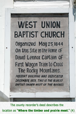
West Union was named by the early pioneers because it was the meeting place, or "union" of the "western frontier". It served as a central stop-over for the Atfalati people as they traveled from their camps near Forest Grove over the Tualatin Mountains to the Willamette River. It served as a trading place and stop for settlers on their way to Portland.
In 1844, seven members of the Baptist Church formed the West Union Baptist Church, in the log cabin home of David T. Lenox (Lenox Elementary School is named for him). In 1853, Lenox donated two acres of land from his donation land claim for a church to be built.
The West Union Baptist Church is the oldest church west of the Rockies. It is listed in the
National Register of Historic Places.
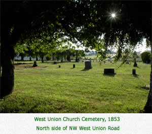
The West Union Church cemetery is the oldest cemetery in Oregon, with its first burial occurring in 1854.
|
|
In 1851, the first school district in Washington County, Oregon Territory, was formed. The school board consisted of David Lenox, Caleb Wilkins and James Chambers. By 1852, funds had been raised and West Union Schools first building was erected on West Union Road.
Today, West Union Elementary School is the oldest continuously operating public school in Oregon.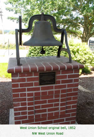 After 150 years, it is now in its third building and its second site. When district consolidation occurred in 1996, West Union School gave its School District No. 1 designation to Hillsboro School District - and thats why you see school buses with 1J on them (J is for the joint counties involved in the consolidation). After 150 years, it is now in its third building and its second site. When district consolidation occurred in 1996, West Union School gave its School District No. 1 designation to Hillsboro School District - and thats why you see school buses with 1J on them (J is for the joint counties involved in the consolidation).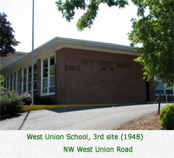
West Union School has been an integral part of the community for the past 150 years. Starting in 1948, the parent club (West Union Community Club) began hosting a ham dinner annually on Veterans Day for the community. Children in each grade contribute in some way to the success of the dinner, from decorating tables, to serving guests, to clearing tables, to providing entertainment. After 60 years, the West Union Ham Dinner continues to attract generations of families who come to enjoy the annual reunion.
Historic Landmarks: Century Farms
Started in 1958, the Oregon Century Farm program was designed to honor families working together for 100 years on their Oregon Farms.
To qualify, the legal owner of the farm must show proof that the farm has been operated continuously by the same family for 100 years or more.
Photographs and a written history are reviewed in the application process.
Each qualifying family receives a certificate, signed by the governor, during a ceremony at the Oregon State Fair.
Families also receive a metal road sign, identifying the historic property, to place in their yard.
Multiple state agencies support this program, including the Oregon Farm Bureau and the Oregon Department of Agriculture.
(11)
 The area north of Highway 26 boasts eight Century Farms, ranging in age from 102 years to 163 years old.
NW West Union Road
Joseph & Mildred Wood Connell II
Century Farm, 1886
NW West Union Road
Batchelder Century Farm, 1858
NW Old West Union Road
Walters Century Farm, 1890
NW North Avenue
Cropp Century Farm, 1907
NW Jackson School Road
Eli Davis Century Farm, 1847
NW Bishop Road
Bishop Century Farm, 1875
NW Helvetia Road
Abraham Yungen Century Farm, 1890
NW Helvetia Road
Pieren Century Farm, 1892
|
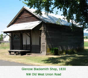
Historic Landmarks: NW Old West Union Road
In 1842, Charley McKay, with his wife, three children and several other families, established the town of Glencoe, near what is now known as North Plains. McKay named the town Glencoe after his birthplace in Scotland. McKay Creek bears his name. Glencoe became a bustling town and trading center. Its residents enjoyed the services of a barber, confectioners, shoe and harness repair shop, hotel, salon, drug store, coffin maker, blacksmith shop, grist mill, and churches. The early freight wagons in 1911 were replaced by the first electric railroad and Glencoe went into a gentle decline. (4)
In 1890, after 60 years of operation, Charley Walters took over ownership of the Glencoe Blacksmith Shop. He operated this shop for another seventy years. Today, 160 years after it was established, it is preserved on the Walters Century Farm on the outskirts of North Plains. (4)
|
Historic Landmarks: NW Jackson Quarry Road
In the early 1850s, John B. Jackson, a relative of Old Hickory Jackson, built the first grist mill and sawmill in the area north of Highway 26 on his 640-acre homestead. The Jackson Grist Mill Site on Jackson Quarry Road is on the State of Oregon Inventory of Historic Sites and Buildings.
The Jackson name has been preserved in other local landmarks: Jackson School Road, Jackson Road, Jackson Creek, Jackson Quarry, Jackson Quarry Road, Jackson Bottom, Jackson Falls.
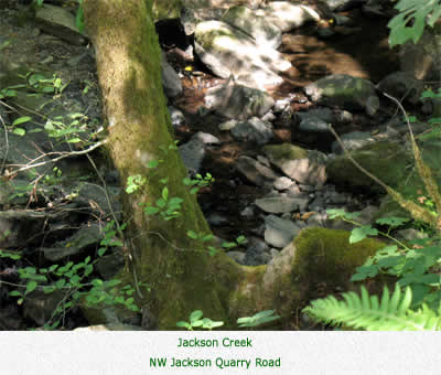 Jackson Creek originates from underground spring headwaters in a canyon east of Moreland Road and just below Skyline Boulevard on the crest of the Tualatin Mountains. About three miles after its headwaters, the creek moves into a ravine. Jackson Falls is formed when the water of Jackson Creek glides over a basalt formation twice the width of the creek and drops 15 feet.
Washington County owned the Falls for 80 to 90 years in conjunction with the nearby quarry operations. Even though it had never been a public recreation area, it has been a very special place to many local residents over the period of 150 years. In 1980, it appeared that Washington County might again open the Jackson Quarry. Three neighbors went together and purchased 40 acres which included the Falls, from Washington County. The Falls is now on privately-owned land. (5)
|
Historic Landmarks: NW Germantown Road
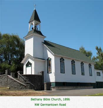 Bethany Bible Church is a heritage church erected by Helvetias Swiss German immigrants. The church was organized in 1889 and the building completed in 1896. Stately in crisp white paint and green trim, it offers a second century of worship to its congregation.
|
Historic Landmarks: NW Helvetia Road
Starting in the 1870s a new wave of settlers began to arrive to make a life in the land north of Highway 26. Hard-working Swiss and German immigrants, they brought their industrious work ethic and love of the land to their new home. Over the next twenty years, about 80 families from Switzerland and Germany settled in the area of Germantown Road and Bethany in the east to Jackson Quarry Road on the west.
It was in 1892 that David Tschabold suggested the name Helvetia to honor Switzerland, the homeland of the majority of the settlers at this time.
Helvetia is Latin for Switzerland, and appears on Swiss coins and stamps.
 Some of the original families names are found on roads throughout the area: Badertscher, Bishop (originally Bischoff), Dick, Dierdorff, Dorland, Grossen, Meier, Phillips (for Phillip Pezoldt), Pubols, Solberger, Schaaf, Stadelman, Yungen.
Helvetia Road is the entrance to historic Helvetia. Bordered on both sides by fertile fields of grains dotted with Oregon white oaks, the fields are now being farmed by the 4th generation of the original Swiss and German immigrants. Using no irrigation, these farmers are highly skilled in selecting the right crops for the foundation soils. Asked about the pristine condition of the fields, Elmer Grossen, 87, says, Were Swiss - we like things clean!
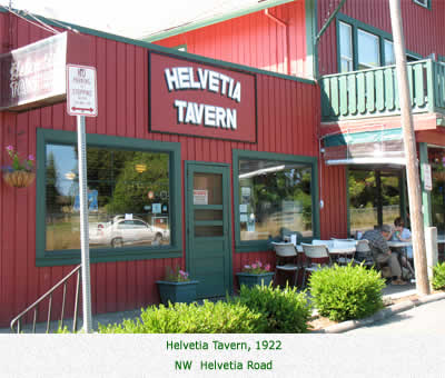 Helvetias landmark tavern, the Helvetia Tavern, was built in 1922 on Helvetia Road as a grocery store and gas station. A tavern opened in the building the very day that Prohibition ended. The tavern operated in the original building until 1948, when the state legislature passed a law that required plumbing in taverns. A fully-plumbed addition was built in front of the original building, where the old taverns outhouse used to stand.
Helvetia Taverns signature burgers, especially its jumbo burgers, draw in the crowds but the country setting of the tavern plays a significant role in attracting the daily overflowing lunch and dinner crowds of tourists, regulars and locals. (9)
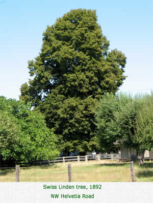 Trees are a special part of Helvetia. As you drive throughout Helvetia, you can see majestic Linden trees, dating from 1892. Local lore has it that twelve Linden seedlings were brought from Switzerland and given to the twelve founding families of the Helvetia Community Church.
Or that the local midwife recommended them to families for their medicinal purposes, such as Linden tea. Whatever the reason, these 60-feet tall gentle giants have graced Helvetias landscape for over 100 years.
Trees are a special part of Helvetia. As you drive throughout Helvetia, you can see majestic Linden trees, dating from 1892. Local lore has it that twelve Linden seedlings were brought from Switzerland and given to the twelve founding families of the Helvetia Community Church.
Or that the local midwife recommended them to families for their medicinal purposes, such as Linden tea. Whatever the reason, these 60-feet tall gentle giants have graced Helvetias landscape for over 100 years.
Helvetia Community Church
 Helvetias signature landmark is the Helvetia Community Church, listed on the State of Oregon Inventory of Historic Sites and Buildings. Founded by Swiss and German settlers, it was organized in 1881 under the German Reformed denomination. The Helvetia Community Church was built in 1899 with 161 days of donated labor. It features a 65-foot steeple, one of the highest in those times. The bell is unusually large and its chimes can be heard through the area. Services were in German until after WW II. In 1957, the congregation reorganized themselves into an independent church and chose the name Helvetia Community Church. The stately church and cemetery are on a rise on NW Helvetia Road which overlooks the Tualatin Valley. (7)
Scenic NW Helvetia Road boasts three Century Farms within one mile. Fourth generation family members continue to farm in the Swiss German tradition.
Bishop Century Farm, 1876
Yungen Century Farm, 1890
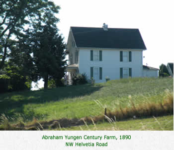 Directly across from the Helvetia Community Church is the Abraham Yungen Century Farm. One of three Jungen brothers to emigrate from Switzerland, the family name was changed to Yungen to reflect the actual pronunciation.
|
Historic Landmarks: NW Dick Road
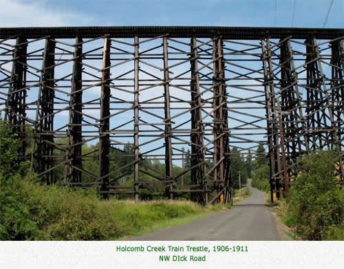
Sometime between 1906 and 1911, the Holcomb Creek Trestle was built by United Railways (UR) as part of the drive to provide electric interurban service between Portland and Banks. It is a timber pile-driven trestle 1,168 feet in length and approximately 90 feet tall. It crosses Dick Road and spans Holcomb Creek.
Train crews sometimes refer to the crossing as the Valley of Wood, because of the volume of wood in the trestle. It is thought to be the highest and longest still-used wooden train trestle in the United States. (10)
The Holcomb Creek trestle was the setting for an episode of "The Nowhere Man" shot in the 1990s.
A copy of the episode is posted on-line.
Note that this is a 50-minute video, and takes a while to load.
The trestle appears in the first minute of the program (and possibly elsewhere).
(Our thanks to Helvetia resident Randy Thurman.)
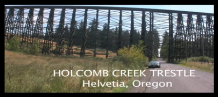 Click the image above to view a short video about the trestle
|
Historic Landmarks: NW Cornelius Pass Road
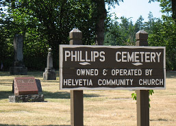 Due to difficulties of travel in the hilly Helvetia area, the congregation of Helvetia Community Church actually built two churches, with two cemeteries: Helvetia Community Church on NW Helvetia Road in 1899 and Phillips Church on NW Cornelius Pass near NW Phillips Road in 1898. They shared one minister, who would alternate Sunday services between the two churches. When the Phillips Church was destroyed by arson in 1938, the two congregations united for worship in the Helvetia Community Church. The Helvetia Community Church members continue to maintain the 111-year-old heritage Phillips Cemetery.
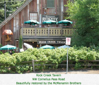 In the early 1900s, Adolph Fuegy, a Swiss immigrant, built a blacksmith shop on Cornelius Pass Road at the T-intersection of Phillips Road. By 1920, his son converted a workmans house on the site to the Rock Creek Store. After prohibition ended in the 1930s, he added a tavern and the Rock Creek Tavern became a hit.
In the 1940s, busloads of Hillsboro residents who worked in the Portland shipyards stopped for the music and the brews. (8) Historic Rock Creek Tavern has provided good food, entertainment and historic ambiance to Portland-area patrons for almost 100 years. (8)
In the early 1900s, Adolph Fuegy, a Swiss immigrant, built a blacksmith shop on Cornelius Pass Road at the T-intersection of Phillips Road. By 1920, his son converted a workmans house on the site to the Rock Creek Store. After prohibition ended in the 1930s, he added a tavern and the Rock Creek Tavern became a hit.
In the 1940s, busloads of Hillsboro residents who worked in the Portland shipyards stopped for the music and the brews. (8) Historic Rock Creek Tavern has provided good food, entertainment and historic ambiance to Portland-area patrons for almost 100 years. (8)
|
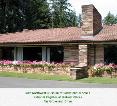
Historic Landmarks: NW Groveland Drive
The Rice Northwest Museum of Rocks and Minerals is the finest rocks and minerals museum in the Pacific Northwest, and one of the best in the nation. It contains the largest opal-filled thunderegg in the world, crystallized gold bigger than a hand, dinosaur eggs and fossils, an extensive meteorite collection and other attractions.
The museum facility, the Richard and Helen Rice Residence, is listed on the National Register of Historic Places. It is recognized for its unique mid-century architectural style, as well as its use of natural stone on the interior and exterior, and the extraordinary woodwork throughout, all of native Oregon woods. (12)
|
Summary
The Helvetia areas many historic landmarks, which date back 150 years, establish the historic and cultural value of this area north of Highway 26 for factor (3)(e). Two National Register of Historic Places, eight Century Farms, two State of Oregon Historic Buildings, twelve Washington County Cultural Resource Inventory sites and one Native American cultural site contribute to the areas regional value for a Sense of Place for factor (3)(e).
Please designate all land north of Highway 26 as Rural Reserve.
|
Works Cited
- Oregon Administrative Rules, Division 27, 660-027-0010, Definitions.
- Washington County Cultural Resource Inventory # 111/27. Recorded September, 1983.
- Benson, Robert L. Article: Historic Roads and Landmarks of Northwest Oregon. Appears in Land of Tuality, Washington County Historical Society, Vol. II, p. 5
- West Union 145 years, a publication of the West Union Community Club, 1951, 1976, 1996. p. 3-53
- Pasley, Ruth, 1983. A Historical Research of Jackson Falls and Jackson Creek, Washington County, Oregon. p. 3-5
- Pezoldt, Louise and Robert L. Benson, 1959. Old Timers of Helvetia and Phillips, Oregon.
- History of Helvetia Community Church. March 6, 2003. On-line: Helvetia Church History
- Chidester, Bill. December 9, 2003. Taverns history traced back nearly 100 years. Hillsboro Argus.
- Gross, Mary. May 8-14, 1985. Helvetia burger maven finds heaven at tavern. The Times.
- Melbo, Bob and Arlen Sheldrake, The History of Holcomb Creek Trestle. July 23, 2009. On-line: http://www.traintrestle.com
- Trappen, Michelle, August 2, 2007. Celebrating a Century, The Oregonian Washington County Weekly, p. 12-14
- Rice NW Museum Information. On-line: Rice NW Museum
- Benson, Robert L, 1974. The Glittering Plain. Land of Tuality, Volume 1. Washington County Historical Society, Hillsboro, Oregon.
|
Acknowledgements
EditorCherry Amabisca
ContributorsElda Harris
Roy Hofer
Dr. Shirley Malcolm
Vern Nussbaumer
The Grossen Family
The Yungen Family
The Merz Family
PhotographsAdrian Amabisca
Mary Pruitt
Cherry Amabisca
Thanks to John Talbot for his assistance in preparing this document for web publication.
|
Next: History of the Swiss in Helvetia
Back to Making our case
|